

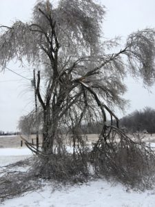
 The ice storm over the weekend was a thing of beauty and disaster. Daniel Huston took the picture of a tree near her farm northeast of Gallatin. The tree lost limbs due to the weight of ice. Terry Jarboe took the picture of an ornamental windmill in the yard of his home on Hwy. CC. He said the blades never stopped spinning and he had to manually stop them to take the picture in dense fog. School districts dismissed school early Jan. 10, as state transportation officials noted roads in northwest Missouri would soon be covered or partially covered in snow or ice. A line stretching from Kansas City to Chillicothe to Kirksville saw rain, freezing rain, sleet, and snow. Four to six inches of snow was reported around Chillicothe and St. Joseph. Areas saw up to a quarter-of-an-inch of ice.
Forecasters are monitoring what they say will be the next multifaceted storm to target the central United States at the end of the week, according to AccuWeather. The storm is expected to bring a variety of hazards to travelers as precipitation will vary from rain to ice to snow amid the midsection of the nation.
Prior to late week, motorists will also need to be wary of several quick-hitting snow events that will sweep through the Midwest.
The late-week storm will first bring accumulating snowfall to places such as Seattle and Portland, Oregon, as well as some rain and snow to California Wednesday into Thursday, before it reaches the Central states on Friday.
Ice is lovely…until the lights go out
Not very many in the area, according to Chasity Anderson, Communications Manager at FEC, Across nine county service area there were 300-350 out of 10,000 members. All were back on within a few hours. A low number was reported Monday with 215 scattered outages because of the ice falling off the line, also repaired quickly.
This website brought to you in part by the following sponsor:

Find out how to advertise here - Email us! [email protected]